


Voting District 7, Hampshire County, West Virginia
About
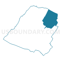
Outline

Summary
| Unique Area Identifier | 690689 |
| Name | Voting District 7 |
| County | Hampshire County |
| State | West Virginia |
| Area (square miles) | 75.03 |
| Land Area (square miles) | 74.26 |
| Water Area (square miles) | 0.77 |
| % of Land Area | 98.97 |
| % of Water Area | 1.03 |
| Latitude of the Internal Point | 39.41643440 |
| Longtitude of the Internal Point | -78.43327160 |
Maps


Graphs
Select a template below for downloading or customizing gragh for Voting District 7, Hampshire County, West Virginia


Neighbors
Neighoring Voting District (by Name) Neighboring Voting District on the Map
- Voting District 11, Hampshire County, WV
- Voting District 13, Morgan County, WV
- Voting District 18, Morgan County, WV
- Voting District 6, Hampshire County, WV
- Voting District 8, Hampshire County, WV
- Voting District 9, Hampshire County, WV
- Gainesborough Voting District, Frederick County, VA
Top 10 Neighboring County Subdivision (by Population) Neighboring County Subdivision on the Map
- Gainesboro district, Frederick County, VA (11,760)
- Gore district, Hampshire County, WV (5,324)
- District 1, Morgan County, WV (4,966)
- Bloomery district, Hampshire County, WV (3,359)
Top 10 Neighboring Unified School District (by Population) Neighboring Unified School District on the Map
- Frederick County Public Schools, VA (78,305)
- Hampshire County School District, WV (23,964)
- Morgan County School District, WV (17,541)
Top 10 Neighboring State Legislative District Lower Chamber (by Population) Neighboring State Legislative District Lower Chamber on the Map
- State House District 29, VA (88,049)
- State House District 51, WV (20,765)
- State House District 50, WV (19,860)
Top 10 Neighboring State Legislative District Upper Chamber (by Population) Neighboring State Legislative District Upper Chamber on the Map
Top 10 Neighboring 111th Congressional District (by Population) Neighboring 111th Congressional District on the Map
Top 10 Neighboring Census Tract (by Population) Neighboring Census Tract on the Map
- Census Tract 503, Frederick County, VA (5,999)
- Census Tract 9682, Hampshire County, WV (5,398)
- Census Tract 9709, Morgan County, WV (2,562)
Top 10 Neighboring 5-Digit ZIP Code Tabulation Area (by Population) Neighboring 5-Digit ZIP Code Tabulation Area on the Map
- 26704, WV (5,663)
- 22625, VA (3,641)
- 26711, WV (2,655)
- 25434, WV (2,521)
- 25422, WV (1,700)
- 25444, WV (605)
- 26817, WV (443)